
Mexico City Bus Map
On this page you will find the Mexico City Metrobús map, the Mexibús map and the trolleybus map. Together with the metro, the commuter rail and the light rail, these bus networks form a key part of public transit in the Mexico City area: Metrobús has 7 bus rapid transit lines, Mexibús has 4 lines serving the neighboring State of Mexico, and the trolleybus network has 15 lines, including the elevated Line 10 (Trolebús Elevado).
Mexico City Metrobus Map
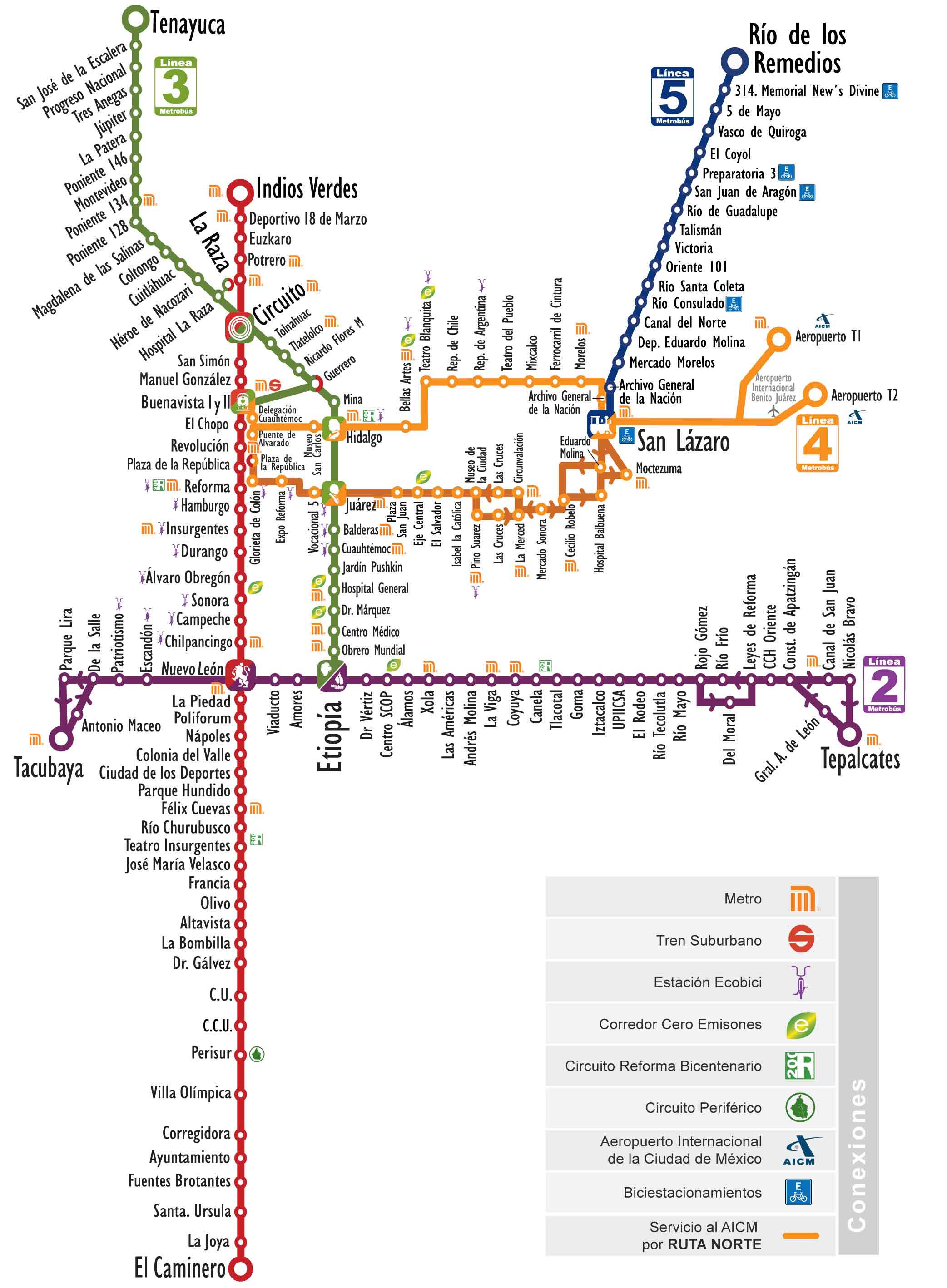
Mexico metrobus map
Mexico City's Metrobús, a bus rapid transit system that opened in 2005, carries about 1.4 million passengers a day.
Its network includes the following 7 lines:
• Line 1: Indios Verdes ↔ El Caminero
• Line 2: Tepalcates ↔ Tacubaya
• Line 3: Tenayuca ↔ Pueblo Santa Cruz Atoyac
• Line 4: Buenavista ↔ San Lázaro, with routes to the airport (Terminals 1 and 2) and Alameda Oriente
• Line 5: Río de los Remedios ↔ Preparatoria 1
• Line 6: El Rosario ↔ Villa de Aragón
• Line 7: Indios Verdes ↔ Campo Marte
Mexico City Mexibus Map
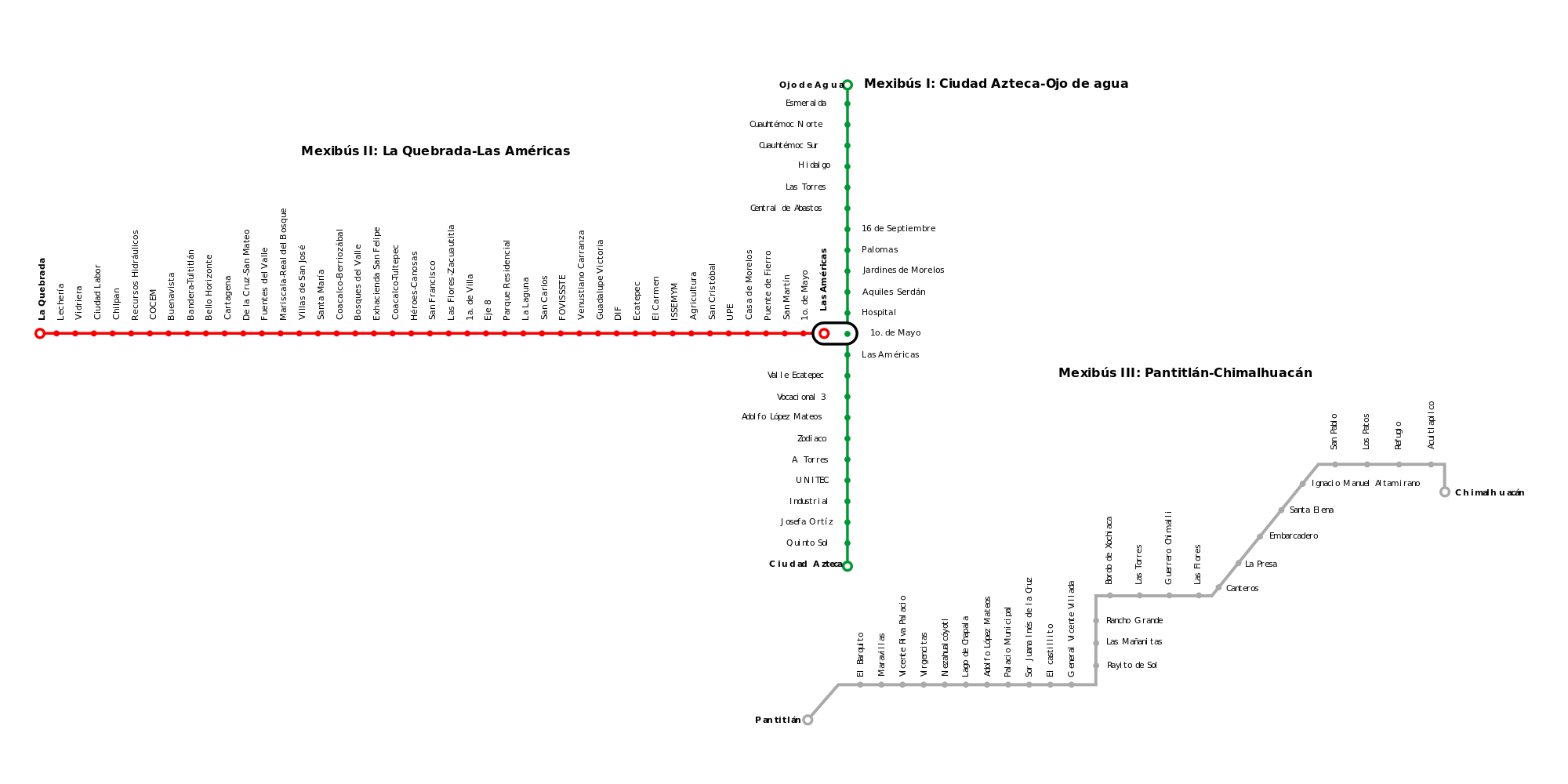
Mexico mexibus map
Mexibús, the bus rapid transit system of the State of Mexico serving Mexico City's northern and eastern suburbs, opened in 2010 and is operated under concession by several companies, including Transmasivo, Transcomunicador Mexiquense and Red de Transporte de Oriente.
Its network includes the following 4 lines:
• Line 1: Ciudad Azteca ↔ Ojo de Agua, extended to Felipe Ángeles International Airport (AIFA)
• Line 2: La Quebrada ↔ Las Américas
• Line 3: Pantitlán ↔ Chimalhuacán
• Line 4: Universidad Mexiquense del Bicentenario ↔ La Raza
Mexico City Trolleybus Map

Mexico trolleybus map
Mexico City's trolleybus network opened in 1951 and is operated by the STE de la Ciudad de México (Servicio de Transportes Eléctricos de la Ciudad de México).
Its network includes the following 15 lines:
• Line 0: Chapultepec ↔ Ciudad Universitaria
• Line 1: Central del Norte ↔ Central del Sur
• Line 2: Chapultepec ↔ Pantitlán
• Line 3: San Andrés Tetepilco ↔ Mixcoac
• Line 4: Boulevard Puerto Aéreo ↔ El Rosario
• Line 5: San Felipe de Jesús ↔ La Diana
• Line 6: El Rosario ↔ Chapultepec
• Line 7: Ciudad Universitaria ↔ Periférico Oriente
• Line 8: Zacatenco (loop)
• Line 9: Villa de Cortés ↔ Tepalcates
• Line 10 (Trolebús Elevado): Constitución de 1917 ↔ Santa Marta
• Line 11: Santa Marta ↔ Chalco
• Line 12: Perisur ↔ Tasqueña
• Line 13: Mixcoac ↔ Constitución de 1917
• Line 14: Universidad ↔ Huipulco